Volatility in the stock market causes alarm, why not in the climate? It certainly does when it shows up in the weather! A couple of days ago, the American public radio broadcaster, NPR, carried a report of a centimeter or so of snow on the ground in Ft. Collins, Colorado, some 48 hours after the thermometers there reached 37.2ºC. To be clear, that apparently set 2 records for extrema: the earliest ground-accumulated snowfall and the highest temperature, for that time of year, ever recorded at Ft. Collins. Records like this are important because they allow comparisons to precedent, and we base our planning for future events on precedent. But with all of the record breaking climate events we’ve seen recently, it’s clear that we need a longer term view of precedent.
Ft. Collins is situated at the eastern edge of the Colorado Plateau, a geologic feature of the North America that may be viewed similarly to the Tibetan Plateau in Asia; that is, as the roof of the continent. Although the highest mountains of the Colorado Plateau, the Rockies, are nowhere near the scale of the Himalaya, their high elevation snowpack is critically important to the flow of the Colorado River, one of the great rivers of the Americas, among others of the American Southwest. It was also home to uniquely sophisticated maize farming cultures of pre-Colombian Southwest. There have been many studies of these maize farming peoples, whose disappearance has long been associated with climate change, drought in particular from ~870 years ago. However, it has been difficult for scientists to rely on proxies that are sufficiently resolved in time and space to make coeval comparisons of climate changes in the region.
While the association between demographic transformation and drought is strongly supported by the evidence, we have tended to over-sample certain proxies like tree rings, and may have become too heavily reliant on narratives informed by these proxies in particular. In short, we know that they are not telling the whole story; and we want to know as much of that story as possible, to reconstruct a history that many of the first European settlers in the area ignored or tried to obliterate, as well as a record of the climate that bears on our shared future in the Southwest, and its growing populations of tens of millions. (Transformation is a better way to think about the classic “collapse” paradigm. For one, these were people who may not have seen themselves as the cohesive unit we have since clumped them into. For another, what appears like collapse to us may simply be that they shifted to other modes of subsistence that left a less durable record for archaeologists to uncover. Furthermore, transformation has a technical meaning that is broader than can be resolved by the archaeology alone: it means a change in the prevailing state, which may be defined by measurable quantities, to another state; hence, a less profound but much more expansive societal transformation, which is bound to appear in some future fossil record, is what was brought about by the recent Covid-19 pandemic.) Another way of measuring higher resolution climate change is with models, in this case with a state-of-the-art climate model that calculates temperature and precipitation as variables independent of proxies like tree rings.
Among the ancient maize farmers of the Southwest were the Fremont, who inhabited the western Colorado Plateau, and eastern edge of the adjacent Great Basin, from ~1600 to around 800 years ago. Even for those without any interest in archaeology, the Fremont are worthy of attention because their mode of subsistence agriculture bound them tightly to changing conditions on the landscape and with the climate. To understand changes in Fremont behaviors during the MCA is potentially to understand how humans will respond to similar changes we expect from modern global warming. To that end, I carried out studies comparing Fremont occupation to temperature and precipitation changes based on a statistically downscaled climate model. (Statistical downscaling is a way of increasing the spatial resolution of the model by analogy with modern climate records.)
Using the downscaled climate model to drive a biophysical crop model specially modified to grow ancient Native American maize, we found that changes in local (over the scale of a dozens of square kilometers, and sub-decadal timescales) temperatures were more important in the lives, practices and habits of the Fremont than changes in regional, long-term (over the scale of hundreds and thousands of square kilometers, and century timescales) temperature conditions. In a follow-on study, I used the same downscaled climatologies to calculate growing season lengths for ancient maize, expanded the geographic range, and used a more sophisticated treatment of Fremont radiocarbon dated occupation likelihoods, and showed that the most populous and resilient Fremont communities were at sites with low-variability season lengths; and low populations coincided with, or followed, periods of variable season lengths. This study confirmed the important dependence on climate variability; and more importantly, our results are in line with others on modern smallholder farming contexts. (I wrote about this in a blog post for my former institute here.)
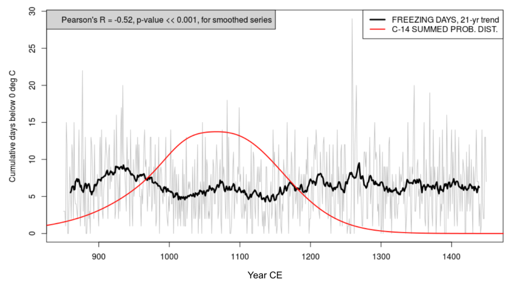
Something that never made it into the final version of the published paper, but was nevertheless interesting, is a model-based calculation of “freeze days”, sometimes termed dying degree days (DDD) analogous to growing degree days (GDD), used to measure growing season lengths. Maize rhizomes (roots) are vulnerable to damage when temperatures are below 4ºC for short periods, and leaf structures can be damaged below freezing (0ºC). The climate model calculates temperature at a test height of 2 meters above ground level, and we cannot say with confidence that the temperature at ground-level, or indeed some 10 cm into the soil, is this cold; however, we can say that the number of days for which low temperatures dominated during the year were least during the period of greatest occupation at several of the Fremont sites we studied (the figure below shows this for Range Creek Canyon, a tributary of the Green River in central-eastern Utah).